For sale · MLS® 1305006
410 Stavanger Drive
St. John's, NL, A1A0A7

List price
$NaN
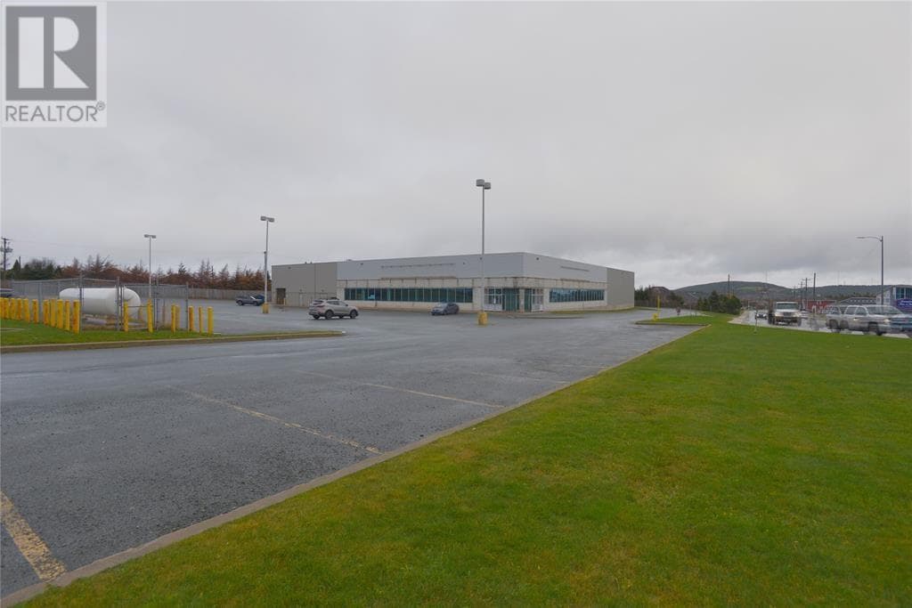

About this propertyMLS® 1305006
Located in the heart of St. John’s thriving commercial district, 410 Stavanger Drive offers over 30,000 square feet of prime retail and warehouse space. Zoned Commercial Regional (CR), this property is ideally suited for a variety of businesses, including retail, distribution, and mixed-use operations. With two dock-level loading doors and one ground-level loading door, it provides seamless logistics and accessibility for shipping and receiving. The property features approximately 100 parking spaces, ensuring ample room for customers and employees. Surrounded by major retailers and positioned in a high-traffic area, this location benefits from strong visibility and a well-established commercial presence. Additionally, its close proximity to major highways allows for convenient transportation and easy connectivity to other parts of the city and beyond. Previously occupied by Princess Auto for 15 years, this space has a proven track record of success for long-term business operations. Whether you’re looking to expand or establish a new presence in St. John’s, 410 Stavanger Drive presents an exceptional opportunity. Lease is Triple Net. (id:56688)
Specifications
Property details
Overview
The home
Systems & utilities
Size & land
Taxes
Parking & outdoor
Features
Fees & source
Room by room
Rooms
The neighbourhood
St. John's at a glance
Live market stats for St. John's — what's for sale, what it costs, how it compares to nearby towns, and how walkable this address is.
Homes for sale here
451
Median list price
$400k
Price range
$1.4k – $4.3M
Typical build
1976
Average size
3,655 sqft
Where St. John's listings are priced
Every active list price in St. John's, grouped into bands.
List price, thousands of $ · 380 homes
View as table
| Price band ($) | Listings |
|---|---|
| <200 | 39 |
| 200–300 | 53 |
| 300–400 | 103 |
| 400–500 | 57 |
| 500–750 | 62 |
| 750–1M | 31 |
| 1M+ | 35 |
How St. John's compares
Median list price against the next biggest markets — click a row for that area guide.



The essentials
Location, air, flood & taxes
Flood (100-yr)
outside the mapped floodplain
Zoning
1.91 ha parcel
Elevation
102 m
0300 mmetres above sea level
Air quality now
1–3 band
110+AQHI 2 · Low risk · St. John's · updated 5:00 p.m.
Climate
Feb -1° · Jul 21°
normal daily high · ST JOHN'S A station · 1981–2010
Amenity constellation
compass view · OpenStreetMap · ODEF schools
Nearby & drive routes
50 places shown · 3 routes · OpenStreetMap · OSRM
- 12 min to downtown St. John's9.4 km
- 7 min to Memorial University5.9 km
- 8 min to Avalon Mall7.5 km
Schools 8
Health 6
Groceries 9
Cafés 6
Parks 12
Bus stops 9
Cost & context
What this home really costs
Winter heat, five years of ownership, how this price sits against the market, and what the map says is within walking distance — every figure captioned with its assumptions.
Winter warmer
Jan–Mar · estimate
$6,642/mo
Est. winter heating (Propane (priced at the electricity rate)) — about $19,927 for January through March.
Estimate — not an appraisal. Propane (priced at the electricity rate) at 15.587¢/kWh (Newfoundland Power, eff. Jul 1 2026, pre-HST). 30,623 sqft. Severity 1.00× St. John's from the ST JOHN'S A station 1981–2010 normal. Jan–Mar only; excludes HST, hot water, cooking and any cooling.
Errand score
walk-time weighted
60
grocery 260 m, school 1.2 km
Nearest errand: Tim Hortons (café) — 120 m, about 2 min on foot.
Walk-time-weighted from OpenStreetMap + ODEF school data; straight-line distance at 4.8 km/h. Weights: grocery 1.0, school 0.9, health 0.8, park 0.4, café 0.35, bus 0.3 — nearest place per category only. Half-value every 6 minutes of walking; nothing scores past a 15-minute walk. 100 = every category at the door. This is a mapping of what's drawn on the map, not a survey of what exists.
Ask this listing
open data · 5 questions
- School within 1 km?No school mapped within 1 km
- Grocery nearby?Yes · 260 mMarie's Mini Mart
- Bus stop?Yes · 210 mStavanger Drive - 391 (Near Allied)
- In the 100-year floodplain?No — outside itCity of St. John's flood map
- Zoning?CR — Commercial Regional1.91 ha parcel
From OpenStreetMap + ODEF schools (straight-line distance) and the City of St. John's flood & zoning maps. Flood and zoning are mapped for St. John's only; elsewhere those questions don't appear because we don't know the answer.
No list price on record — carrying costs appear once the feed sends one.
Plan ahead
Calculators
Estimate payments and returns before you make an offer — all in one place.
Get in touch
Have a question?
Send a message and Haris will get back to you — usually the same day.

Talk to Haris
A real person, every time
Buying, selling, or just curious about what your home is worth — no call centres, no runaround.
- Call or text416-873-4676
- Emailharis@barki.co
- Office17 Duffy Place, Suite 200, St. John's
Keller Williams Platinum Realty
Your details go straight to Haris — never shared, never spammed.